
Château de Sassenage topographic map
Interactive map
Click on the map to display elevation.
About this map
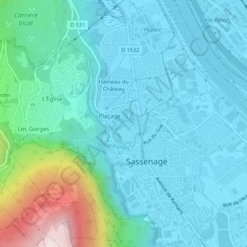
Name: Château de Sassenage topographic map, elevation, terrain.
Average elevation: 1,122 ft
Minimum elevation: 643 ft
Maximum elevation: 3,458 ft
Other topographic maps
Click on a map to view its topography, its elevation and its terrain.
Cuves de Sassenage
France > Auvergne-Rhône-Alpes > Isère > Sassenage > Hameau du Château
Cuves de Sassenage, Sentier du Furon, Plaçage, Hameau du Château, Sassenage, Grenoble, Isère, Auvergne-Rhône-Alpes, France métropolitaine, 38360, France
Average elevation: 1,526 ft