
Puthuppally topographic map
Interactive map
Click on the map to display elevation.
About this map
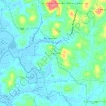
Name: Puthuppally topographic map, elevation, terrain.
Location: Puthuppally, Kottayam, Kerala, 686011, India (9.53930 76.55194 9.57930 76.59194)
Average elevation: 59 ft
Minimum elevation: -10 ft
Maximum elevation: 259 ft
Other topographic maps
Click on a map to view its topography, its elevation and its terrain.
Thiruvanchoor
India > Kerala > Kottayam > Thiruvanchoor
Thiruvanchoor, Kottayam, Kerala, 686637, India
Average elevation: 36 ft
Karappuzha Temple Kulam
India > Kerala > Kottayam > Kottayam
Karappuzha Temple Kulam, Kottayam, Kerala, India
Average elevation: 20 ft
Mattakkara
India > Kerala > Kottayam > Mattakkara
Mattakkara, Kottayam, Kerala, 686564, India
Average elevation: 135 ft