
Altentreptow topographic map
Interactive map
Click on the map to display elevation.
About this map
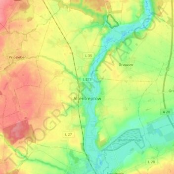
Name: Altentreptow topographic map, elevation, terrain.
Average elevation: 118 ft
Minimum elevation: 10 ft
Maximum elevation: 243 ft
Other topographic maps
Click on a map to view its topography, its elevation and its terrain.
Roez
Allemagne > Mecklembourg-Poméranie-Occidentale > Mecklenburgische Seenplatte
Roez, Göhren-Lebbin, Malchow, Mecklenburgische Seenplatte, Mecklembourg-Poméranie-Occidentale, Allemagne
Average elevation: 279 ft
Warlin
Allemagne > Mecklembourg-Poméranie-Occidentale > Mecklenburgische Seenplatte > Sponholz > Warlin
Warlin, Sponholz, Neverin, Mecklenburgische Seenplatte, Mecklembourg-Poméranie-Occidentale, 17039, Allemagne
Average elevation: 135 ft