
Chão do Galego topographic map
Interactive map
Click on the map to display elevation.
About this map
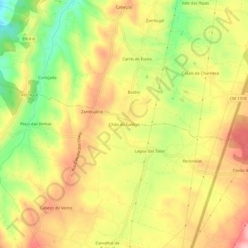
Name: Chão do Galego topographic map, elevation, terrain.
Location: Chão do Galego, Turquel, Alcobaça, Leiria, 2460-795, Portugal (39.46876 -8.97598 39.50876 -8.93598)
Average elevation: 551 ft
Minimum elevation: 249 ft
Maximum elevation: 797 ft
Other topographic maps
Click on a map to view its topography, its elevation and its terrain.
Casal de Vale de Ventos
Casal de Vale de Ventos, Turquel, Alcobaça, Leiria, 2040-015, Portugal
Average elevation: 1,198 ft
Ataíja de Baixo
Ataíja de Baixo, Aljubarrota, Alcobaça, Leiria, 2460-613, Portugal
Average elevation: 535 ft