
Obstfelderschmiede topographic map
Interactive map
Click on the map to display elevation.
About this map
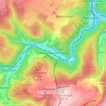
Name: Obstfelderschmiede topographic map, elevation, terrain.
Average elevation: 1,663 ft
Minimum elevation: 1,027 ft
Maximum elevation: 2,274 ft
Other topographic maps
Click on a map to view its topography, its elevation and its terrain.
Meuselbach
Deutschland > Thüringen > Landkreis Saalfeld-Rudolstadt > Schwarzatal
Meuselbach, Schwarzatal, Landkreis Saalfeld-Rudolstadt, Thüringen, Deutschland
Average elevation: 1,903 ft
Meuselbacher Kuppe
Deutschland > Thüringen > Landkreis Saalfeld-Rudolstadt > Schwarzatal
Meuselbacher Kuppe, Schwarzatal, Landkreis Saalfeld-Rudolstadt, Thüringen, 98744, Deutschland
Average elevation: 2,087 ft
Oberweißbach/Thüringer Wald
Deutschland > Thüringen > Landkreis Saalfeld-Rudolstadt > Schwarzatal
Oberweißbach/Thüringer Wald, Schwarzatal, Landkreis Saalfeld-Rudolstadt, Thüringen, 98744, Deutschland
Average elevation: 1,936 ft
Lichtenhain
Deutschland > Thüringen > Landkreis Saalfeld-Rudolstadt > Schwarzatal > Lichtenhain
Lichtenhain, Schwarzatal, Landkreis Saalfeld-Rudolstadt, Thüringen, 98744, Deutschland
Average elevation: 1,834 ft
Meuselbach-Schwarzmühle
Deutschland > Thüringen > Landkreis Saalfeld-Rudolstadt > Schwarzatal
Meuselbach-Schwarzmühle, Schwarzatal, Landkreis Saalfeld-Rudolstadt, Thüringen, Deutschland
Average elevation: 1,808 ft
Mellenbach-Glasbach
Deutschland > Thüringen > Landkreis Saalfeld-Rudolstadt > Schwarzatal
Mellenbach-Glasbach, Schwarzatal, Landkreis Saalfeld-Rudolstadt, Thüringen, Deutschland
Average elevation: 1,680 ft