Make a donation
Gear up for your next adventure:
As an Amazon Associate, this site earns from qualifying purchases at no extra cost to you.
Eudora topographic map
Click on the map to display elevation.
Make a donation
Gear up for your next adventure:
As an Amazon Associate, this site earns from qualifying purchases at no extra cost to you.
About this map
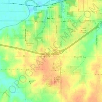
Name: Eudora topographic map, elevation, terrain.
Location: Eudora, Douglas County, Kansas, 66025, United States (38.90958 -95.12117 38.95069 -95.07026)
Average elevation: 873 ft
Minimum elevation: 797 ft
Maximum elevation: 925 ft
Douglas County trails, hiking, mountain biking, running and outdoor activities
Make a donation
Gear up for your next adventure:
As an Amazon Associate, this site earns from qualifying purchases at no extra cost to you.
Other topographic maps
Click on a map to view its topography, its elevation and its terrain.
Lawrence
United States > Kansas > Douglas County > Lawrence
Downtown Lawrence is located at 38°58′18″N 95°14′7″W / 38.97167°N 95.23528°W / 38.97167; -95.23528 (38.959902, −95.253199), approximately 25 miles (40 kilometers) east of Topeka, and 35 mi (56 km) west of Kansas City, Kansas. Though Lawrence has a designated elevation of 866 feet (264…
Average elevation: 928 ft
