
Make a donation
Gear up for your next adventure:
As an Amazon Associate, this site earns from qualifying purchases at no extra cost to you.
Bixby topographic map
Click on the map to display elevation.
Make a donation
Gear up for your next adventure:
As an Amazon Associate, this site earns from qualifying purchases at no extra cost to you.
Bixby
Bixby is located at 35°57′39″N 95°52′42″W / 35.96083°N 95.87833°W / 35.96083; -95.87833 (35.960898, −95.878258). According to the United States Census Bureau, the city has a total area of 25.1 square miles (65.0 km2), of which 24.0 square miles (62.3 km2) is land and 1.0 square mile (2.7 km2) (4.15%) is water. The average elevation is 750 ft (230 m) above MSL. The town is bisected into north and south portions by the Arkansas River; the original town center is located south of the river.
Make a donation
Gear up for your next adventure:
As an Amazon Associate, this site earns from qualifying purchases at no extra cost to you.
About this map
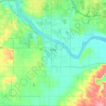
Name: Bixby topographic map, elevation, terrain.
Location: Bixby, Tulsa, Oklahoma, 74008, United States (35.85590 -95.96187 36.01739 -95.76210)
Average elevation: 669 ft
Minimum elevation: 561 ft
Maximum elevation: 965 ft
Tulsa trails, hiking, mountain biking, running and outdoor activities
Make a donation
Gear up for your next adventure:
As an Amazon Associate, this site earns from qualifying purchases at no extra cost to you.
Other topographic maps
Click on a map to view its topography, its elevation and its terrain.