Geolocate

Overlea topographic map

Click on the map to display elevation.

About this map

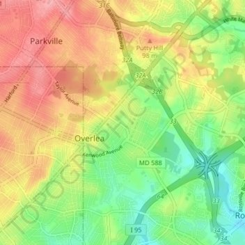
Name: Overlea topographic map, elevation, terrain.

Location: Overlea, Baltimore County, Maryland, United States (39.33475 -76.52972 39.38586 -76.50046)

Average elevation: 207 ft

Minimum elevation: 26 ft

Maximum elevation: 397 ft

Baltimore County trails, hiking, mountain biking, running and outdoor activities

Gear up for your next adventure:

🌡️Portable Weather Meter - Track weather conditions on the trail
🥾Men's Hiking Boots - Durable, waterproof footwear for rugged terrain and steep inclines
🧭Orienteering Set - Complete compass and map reading kit
🧣Hiking Neck Gaiter - Multi‑use neck protection for outdoor weather
🔦LED Headlamp - Bright and durable LED headlamp for night navigation

As an Amazon Associate, this site earns from qualifying purchases at no extra cost to you.