
Parc naturel régional de la Narbonnaise en Méditerranée topographic map
Interactive map
Click on the map to display elevation.
About this map
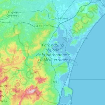
Name: Parc naturel régional de la Narbonnaise en Méditerranée topographic map, elevation, terrain.
Average elevation: 302 ft
Minimum elevation: -16 ft
Maximum elevation: 2,287 ft
Other topographic maps
Click on a map to view its topography, its elevation and its terrain.
Étang de Bages
Étang de Bages, Chemin de l'Olivier et des Etangs, L'Aragnou, Sigean, Narbonne, Aude, Occitanie, France métropolitaine, 11130, France
Average elevation: 82 ft