
Nord topographic map
Interactive map
Click on the map to display elevation.
About this map
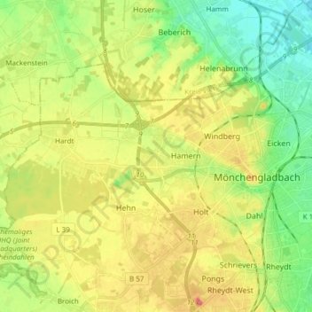
Name: Nord topographic map, elevation, terrain.
Location: Nord, Mönchengladbach, Noordrijn-Westfalen, Duitsland (51.17295 6.31288 51.22913 6.46373)
Average elevation: 223 ft
Minimum elevation: 108 ft
Maximum elevation: 371 ft
Other topographic maps
Click on a map to view its topography, its elevation and its terrain.
Donk
Duitsland > Noordrijn-Westfalen > Mönchengladbach
Donk, Bettrath-Hoven, Ost, Mönchengladbach, Noordrijn-Westfalen, 41066, Duitsland
Average elevation: 128 ft
Rheydt
Duitsland > Noordrijn-Westfalen > Mönchengladbach
Rheydt, Süd, Mönchengladbach, Noordrijn-Westfalen, 41236, Duitsland
Average elevation: 203 ft