
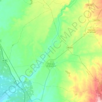
Villanueva de Alcardete topographic map
Interactive map
Click on the map to display elevation.
About this map
Name: Villanueva de Alcardete topographic map, elevation, terrain.
Average elevation: 2,431 ft
Minimum elevation: 2,241 ft
Maximum elevation: 2,848 ft
Other topographic maps
Click on a map to view its topography, its elevation and its terrain.
Mora
Spain > Castile-La Mancha > Mancha Alta de Toledo
Mora, Mancha Alta de Toledo, Toledo, Castile-La Mancha, 45400, Spain
Average elevation: 2,352 ft
Sierra Bermeja
Spain > Castile-La Mancha > Mancha Alta de Toledo > Consuegra
Sierra Bermeja, Consuegra, Mancha Alta de Toledo, Toledo, Castile-La Mancha, Spain
Average elevation: 2,549 ft