
Make a donation
Gear up for your next adventure:
As an Amazon Associate, this site earns from qualifying purchases at no extra cost to you.
Craponne-sur-Arzon topographic map
Click on the map to display elevation.
Make a donation
Gear up for your next adventure:
As an Amazon Associate, this site earns from qualifying purchases at no extra cost to you.
Craponne-sur-Arzon
Located on a granitic plateau mostly situated at more than 900 meters elevation, the commune has a minimum elevation of 771 meters, near the Bois de l'Or along the river Ance in the south-east part of the commune. Its maximum elevation is about 1063 meters, the highest point being located near the place called Le Fêtre, in the north of the town.
Make a donation
Gear up for your next adventure:
As an Amazon Associate, this site earns from qualifying purchases at no extra cost to you.
About this map
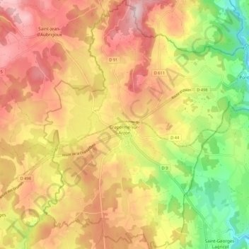
Name: Craponne-sur-Arzon topographic map, elevation, terrain.
Average elevation: 3,048 ft
Minimum elevation: 2,533 ft
Maximum elevation: 3,468 ft
Make a donation
Gear up for your next adventure:
As an Amazon Associate, this site earns from qualifying purchases at no extra cost to you.
Other topographic maps
Click on a map to view its topography, its elevation and its terrain.
Make a donation
Gear up for your next adventure:
As an Amazon Associate, this site earns from qualifying purchases at no extra cost to you.
Cheneville
France > Auvergne-Rhône-Alpes > Haute-Loire > Varennes-Saint-Honorat
Average elevation: 3,461 ft
La Celle
France > Auvergne-Rhône-Alpes > Haute-Loire > Le Chambon-sur-Lignon
Average elevation: 3,192 ft
Laniac
France > Auvergne-Rhône-Alpes > Haute-Loire > Siaugues-Sainte-Marie > Siaugues-Saint-Romain
Average elevation: 2,982 ft
Make a donation
Gear up for your next adventure:
As an Amazon Associate, this site earns from qualifying purchases at no extra cost to you.
Chambonnet
France > Auvergne-Rhône-Alpes > Haute-Loire > Saint-Préjet-d'Allier
Average elevation: 3,196 ft
Make a donation
Gear up for your next adventure:
As an Amazon Associate, this site earns from qualifying purchases at no extra cost to you.
Gashon
France > Auvergne-Rhône-Alpes > Haute-Loire > Saint-Bonnet-le-Froid
Average elevation: 3,409 ft
Make a donation
Gear up for your next adventure:
As an Amazon Associate, this site earns from qualifying purchases at no extra cost to you.