
Belisario Quevedo topographic map
Interactive map
Click on the map to display elevation.
About this map
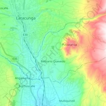
Name: Belisario Quevedo topographic map, elevation, terrain.
Location: Belisario Quevedo, Latacunga, Cotopaxi, Ecuador (-1.01276 -78.60332 -0.93952 -78.47606)
Average elevation: 9,662 ft
Minimum elevation: 8,632 ft
Maximum elevation: 12,139 ft
Other topographic maps
Click on a map to view its topography, its elevation and its terrain.
San Juan de Pastocalle
Ecuador > Cotopaxi > Latacunga
San Juan de Pastocalle, Latacunga, Cotopaxi, Ecuador
Average elevation: 11,368 ft
Pastocalle
Ecuador > Cotopaxi > Latacunga > Latacunga
Pastocalle, Latacunga, Cotopaxi, 050108, Ecuador
Average elevation: 9,354 ft
El Salvario
Ecuador > Cotopaxi > Latacunga > Latacunga > El Salvario
El Salvario, Latacunga, Cotopaxi, 050108, Ecuador
Average elevation: 9,245 ft