Geolocate

Sis topographic map

Click on the map to display elevation.

About this map

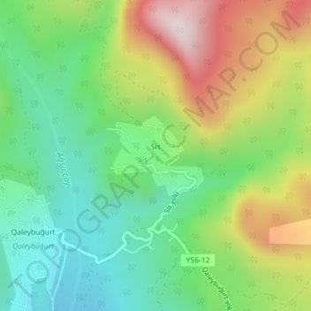
Name: Sis topographic map, elevation, terrain.

Location: Sis, Shamakhi District, Mountainous Shirvan, Azerbaijan (40.75852 48.57564 40.76548 48.58603)

Average elevation: 3,599 ft

Minimum elevation: 2,844 ft

Maximum elevation: 4,826 ft

Other topographic maps

Click on a map to view its topography, its elevation and its terrain.

Shamakhi District

Azerbaijan > Mountainous Shirvan

Average elevation: 2,382 ft

Mountainous Shirvan

Azerbaijan > Mountainous Shirvan

Average elevation: 2,333 ft

Gear up for your next adventure:

🧭GPS Watch Accessories - Bands and chargers for GPS watches
📷Action Cameras - Rugged cameras to document your journeys across rugged terrain
🧴Hand Sanitizer - Keep hands clean while hiking
🧭Outdoor Navigation Book - Learn advanced navigation skills
🏫Relief Map Kits - Hands-on tools for teaching landforms and elevation

As an Amazon Associate, this site earns from qualifying purchases at no extra cost to you.