
Kuwohi topographic map
Interactive map
Click on the map to display elevation.
Kuwohi
At an elevation of 6,643 feet (2,025 m), it is the highest mountain in the Great Smoky Mountains National Park, the highest point in the state of Tennessee, and the highest point along the 2,192-mile (3,528 km) Appalachian Trail. It is also the third highest point in eastern mainland North America, after Mount Mitchell (6,684 feet or 2,037 meters) and Mount Craig (6,647 feet or 2,026 meters).
About this map
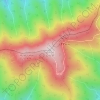
Name: Kuwohi topographic map, elevation, terrain.
Location: Kuwohi, Swain County, North Carolina, United States (35.56281 -83.49843 35.56291 -83.49833)
Average elevation: 5,630 ft
Minimum elevation: 4,495 ft
Maximum elevation: 6,631 ft
Swain County trails, hiking, mountain biking, running and outdoor activities
Other topographic maps
Click on a map to view its topography, its elevation and its terrain.
Fontana Lake
United States > North Carolina > Swain County
Fontana Lake provides the only access into the most remote areas of the National Park, unless visitors undertake a multi-day hike to get there. When the lake is at the normal summer level, a boat may be used to access remote trailheads such as Hazel Creek. From the observation tower on Kuwohi, on a clear day…
Average elevation: 2,644 ft
Fontana Dam
United States > North Carolina > Swain County
Fontana Dam is 2,365 feet (721 m) long and 480 feet (146 m) high, making it the tallest dam in the Eastern United States. The dam has a flood storage capacity of 513,965 acre-feet (633,966,000 m3), and the combined capacity of its three generators is 293.6 megawatts. Fontana Lake has 238 miles (383 km) of…
Average elevation: 1,722 ft