
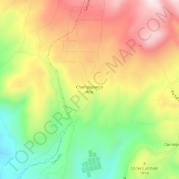
Champapongo Alto topographic map
Interactive map
Click on the map to display elevation.
About this map
Name: Champapongo Alto topographic map, elevation, terrain.
Location: Champapongo Alto, Salcedo, Cotopaxi, Ecuador (-1.03963 -78.52157 -0.99963 -78.48157)
Average elevation: 11,125 ft
Minimum elevation: 10,098 ft
Maximum elevation: 12,162 ft
Other topographic maps
Click on a map to view its topography, its elevation and its terrain.
Champapongo Bajo
Ecuador > Cotopaxi > Salcedo > Salcedo
Champapongo Bajo, Salcedo, Cotopaxi, Ecuador
Average elevation: 10,210 ft
San Miguel de Salcedo
Ecuador > Cotopaxi > Salcedo > Salcedo
San Miguel de Salcedo, Salcedo, Cotopaxi, 050555, Ecuador
Average elevation: 8,898 ft