
Hontomín topographic map
Interactive map
Click on the map to display elevation.
About this map
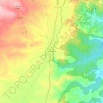
Name: Hontomín topographic map, elevation, terrain.
Average elevation: 3,018 ft
Minimum elevation: 2,635 ft
Maximum elevation: 3,415 ft
Other topographic maps
Click on a map to view its topography, its elevation and its terrain.
Cernégula
España > Castilla y León > Merindad de Río Ubierna
Cernégula, Merindad de Río Ubierna, Burgos, Castilla y León, España
Average elevation: 3,307 ft
Quintanarrío
España > Castilla y León > Merindad de Río Ubierna > Quintanarrío
Quintanarrío, Merindad de Río Ubierna, Burgos, Castilla y León, España
Average elevation: 3,110 ft