Geolocate

Balatan topographic map

Click on the map to display elevation.

About this map

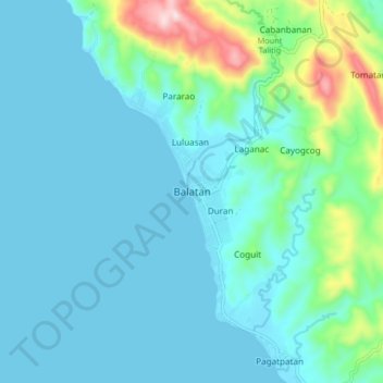
Name: Balatan topographic map, elevation, terrain.

Location: Balatan, Camarines Sur, Bicol Region, 4436, Philippines (13.27667 123.19333 13.35667 123.27333)

Average elevation: 210 ft

Minimum elevation: 0 ft

Maximum elevation: 1,319 ft

Other topographic maps

Click on a map to view its topography, its elevation and its terrain.

Del Gallego

Philippines > Camarines Sur

Average elevation: 299 ft

Sagñay

Philippines > Camarines Sur

Average elevation: 535 ft

Caramoan

Philippines > Camarines Sur

Average elevation: 138 ft

Gear up for your next adventure:

📻Weather Alert Radios - Stay informed of storm risks while off-the-grid
🔋Rechargeable Batteries - Power up your outdoor devices
🎁Geography Themed Gifts - Unique gift ideas for map lovers and geography enthusiasts
💧Water Purification System - Clean water on the trail with reliable purifiers
🧴Hand Sanitizer - Keep hands clean while hiking

As an Amazon Associate, this site earns from qualifying purchases at no extra cost to you.