
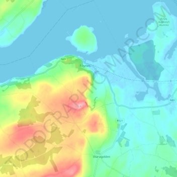
Shanagolden topographic map
Interactive map
Click on the map to display elevation.
About this map
Name: Shanagolden topographic map, elevation, terrain.
Average elevation: 131 ft
Minimum elevation: -16 ft
Maximum elevation: 548 ft
Other topographic maps
Click on a map to view its topography, its elevation and its terrain.
Knocknabooly East
Ireland > The Municipal District of Adare — Rathkeale
Knocknabooly East, Loghill, The Municipal District of Adare — Rathkeale, County Limerick, Munster, Ireland
Average elevation: 344 ft
Glendiheen
Ireland > The Municipal District of Adare — Rathkeale
Glendiheen, Dunmoylan East, The Municipal District of Adare — Rathkeale, County Limerick, Munster, Ireland
Average elevation: 548 ft
Pallaskenry
Ireland > The Municipal District of Adare — Rathkeale
Pallaskenry, The Municipal District of Adare — Rathkeale, County Limerick, Munster, Ireland
Average elevation: 36 ft
Loghill
Ireland > The Municipal District of Adare — Rathkeale
Loghill, The Municipal District of Adare — Rathkeale, County Limerick, Munster, Ireland
Average elevation: 226 ft
Ballinknockane
Ireland > The Municipal District of Adare — Rathkeale
Ballinknockane, Craggs, The Municipal District of Adare — Rathkeale, County Limerick, Munster, Ireland
Average elevation: 89 ft
Inchinclare
Ireland > The Municipal District of Adare — Rathkeale
Inchinclare, Ballynabanoge, The Municipal District of Adare — Rathkeale, County Limerick, Munster, Ireland
Average elevation: 135 ft
Clonshire Beg
Ireland > The Municipal District of Adare — Rathkeale
Clonshire Beg, Croagh, The Municipal District of Adare — Rathkeale, County Limerick, Munster, Ireland
Average elevation: 43 ft
Foynes Island
Ireland > The Municipal District of Adare — Rathkeale
Foynes Island, Shanagolden, The Municipal District of Adare — Rathkeale, County Limerick, Munster, Ireland
Average elevation: 33 ft
Kildimo
Ireland > The Municipal District of Adare — Rathkeale
Kildimo, The Municipal District of Adare — Rathkeale, County Limerick, Munster, Ireland
Average elevation: 46 ft