
Make a donation
Gear up for your next adventure:
As an Amazon Associate, this site earns from qualifying purchases at no extra cost to you.
Stenico topographic map
Click on the map to display elevation.
Make a donation
Gear up for your next adventure:
As an Amazon Associate, this site earns from qualifying purchases at no extra cost to you.
About this map
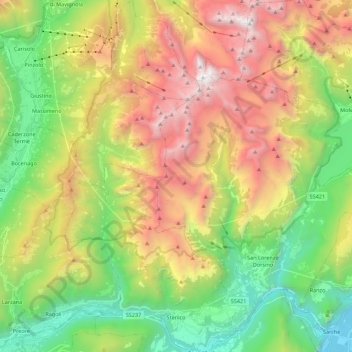
Name: Stenico topographic map, elevation, terrain.
Average elevation: 4,738 ft
Minimum elevation: 794 ft
Maximum elevation: 10,292 ft
Make a donation
Gear up for your next adventure:
As an Amazon Associate, this site earns from qualifying purchases at no extra cost to you.
Other topographic maps
Click on a map to view its topography, its elevation and its terrain.
Sardagna
Italy > Trentino – Alto Adige/Südtirol > Provincia di Trento > Trento
Average elevation: 1,900 ft
Tuenno
Italy > Trentino – Alto Adige/Südtirol > Provincia di Trento > Ville d'Anaunia
Average elevation: 2,441 ft
Sopramonte
Italy > Trentino – Alto Adige/Südtirol > Provincia di Trento > Trento
Average elevation: 2,356 ft
Make a donation
Gear up for your next adventure:
As an Amazon Associate, this site earns from qualifying purchases at no extra cost to you.
Vignole
Italy > Trentino – Alto Adige/Südtirol > Provincia di Trento > Arco > Bolognano
Average elevation: 1,273 ft
Make a donation
Gear up for your next adventure:
As an Amazon Associate, this site earns from qualifying purchases at no extra cost to you.
Colder
Italy > Trentino – Alto Adige/Südtirol > Provincia di Trento > Tiarno di Sopra
Average elevation: 3,173 ft
Val Lasties
Italy > Trentino – Alto Adige/Südtirol > Provincia di Trento > Canazei
Average elevation: 8,346 ft