
Tête des Faux topographic map
Interactive map
Click on the map to display elevation.
About this map
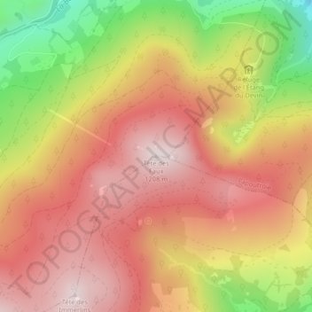
Name: Tête des Faux topographic map, elevation, terrain.
Average elevation: 3,261 ft
Minimum elevation: 2,169 ft
Maximum elevation: 3,950 ft
Other topographic maps
Click on a map to view its topography, its elevation and its terrain.
Les Basses Huttes
France > Grand Est > Haut-Rhin > Orbey
Les Basses Huttes, Orbey, Colmar-Ribeauvillé, Haut-Rhin, Grand Est, France métropolitaine, 68370, France
Average elevation: 2,654 ft
Les Hautes-Huttes
France > Grand Est > Haut-Rhin > Orbey
Les Hautes-Huttes, Orbey, Colmar-Ribeauvillé, Haut-Rhin, Grand Est, France métropolitaine, 68370, France
Average elevation: 2,848 ft
Auberge-Refuge Le Blancrupt
France > Grand Est > Haut-Rhin > Orbey
Auberge-Refuge Le Blancrupt, D 48II, Orbey, Colmar-Ribeauvillé, Haut-Rhin, Grand Est, France métropolitaine, 68370, France
Average elevation: 3,543 ft