
Mostar topographic map
Click on the map to display elevation.
About this map
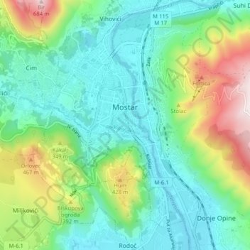
Name: Mostar topographic map, elevation, terrain.
Average elevation: 725 ft
Minimum elevation: 121 ft
Maximum elevation: 2,283 ft
Other topographic maps
Click on a map to view its topography, its elevation and its terrain.
Fortica
Bosnia and Herzegovina > Federation of Bosnia and Herzegovina > City of Mostar > Suhi Do
Average elevation: 1,188 ft
Rodoč
Bosnia and Herzegovina > Federation of Bosnia and Herzegovina > City of Mostar > Local community Rodoč I
Average elevation: 433 ft
Hodbina
Bosnia and Herzegovina > Federation of Bosnia and Herzegovina > City of Mostar
Average elevation: 417 ft