
Thank you for supporting this site ❤️
Make a donation
Make a donation
Gear up for your next adventure:
As an Amazon Associate, this site earns from qualifying purchases at no extra cost to you.
Oberstaufen topographic map
Click on the map to display elevation.
Thank you for supporting this site ❤️
Make a donation
Make a donation
Gear up for your next adventure:
As an Amazon Associate, this site earns from qualifying purchases at no extra cost to you.
About this map
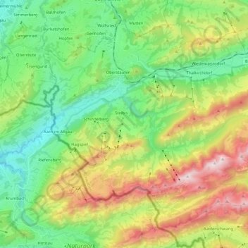
Name: Oberstaufen topographic map, elevation, terrain.
Location: Oberstaufen, Landkreis Oberallgäu, Bavaria, 87534, Germany (47.46563 9.95842 47.58342 10.16510)
Average elevation: 3,261 ft
Minimum elevation: 1,827 ft
Maximum elevation: 5,965 ft
Thank you for supporting this site ❤️
Make a donation
Make a donation
Gear up for your next adventure:
As an Amazon Associate, this site earns from qualifying purchases at no extra cost to you.