
Make a donation
Gear up for your next adventure:
As an Amazon Associate, this site earns from qualifying purchases at no extra cost to you.
New Sharon topographic map
Click on the map to display elevation.
Make a donation
Gear up for your next adventure:
As an Amazon Associate, this site earns from qualifying purchases at no extra cost to you.
About this map
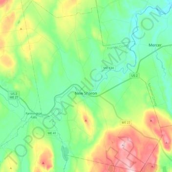
Name: New Sharon topographic map, elevation, terrain.
Location: New Sharon, Franklin County, Maine, 04955, United States (44.57464 -70.08736 44.71471 -69.92817)
Average elevation: 502 ft
Minimum elevation: 174 ft
Maximum elevation: 1,214 ft
Franklin County trails, hiking, mountain biking, running and outdoor activities
Make a donation
Gear up for your next adventure:
As an Amazon Associate, this site earns from qualifying purchases at no extra cost to you.
Other topographic maps
Click on a map to view its topography, its elevation and its terrain.
Caribou Mountain
United States > Maine > Franklin County > Skinner Township
Average elevation: 2,835 ft
Caribou Mountain
United States > Maine > Franklin County > Skinner Township
Average elevation: 2,835 ft
Mount Abraham
United States > Maine > Franklin County > Mount Abram Township
Average elevation: 3,012 ft
Make a donation
Gear up for your next adventure:
As an Amazon Associate, this site earns from qualifying purchases at no extra cost to you.