
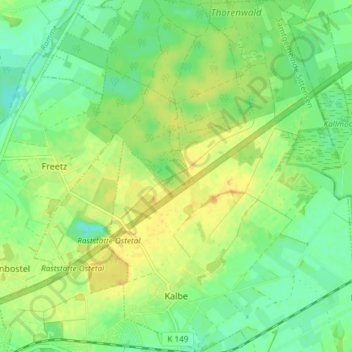
Kalbe topographic map
Interactive map
Click on the map to display elevation.
About this map
Name: Kalbe topographic map, elevation, terrain.
Average elevation: 125 ft
Minimum elevation: 82 ft
Maximum elevation: 164 ft
Other topographic maps
Click on a map to view its topography, its elevation and its terrain.
Beeke
Germany > Lower Saxony > Landkreis Rotenburg (Wümme) > Scheeßel
Beeke, Scheeßel, Landkreis Rotenburg (Wümme), Lower Saxony, Germany
Average elevation: 105 ft
Tiste
Germany > Lower Saxony > Landkreis Rotenburg (Wümme)
Tiste, Samtgemeinde Sittensen, Landkreis Rotenburg (Wümme), Lower Saxony, Germany
Average elevation: 115 ft
Hastenbeck
Germany > Lower Saxony > Landkreis Rotenburg (Wümme) > Deinstedt
Hastenbeck, Deinstedt, Samtgemeinde Selsingen, Landkreis Rotenburg (Wümme), Lower Saxony, Germany
Average elevation: 75 ft
Heinrichsdorf
Germany > Lower Saxony > Landkreis Rotenburg (Wümme) > Sandbostel > Heinrichsdorf
Heinrichsdorf, Sandbostel, Samtgemeinde Selsingen, Landkreis Rotenburg (Wümme), Lower Saxony, Germany
Average elevation: 33 ft
Abbendorf
Germany > Lower Saxony > Landkreis Rotenburg (Wümme) > Scheeßel > Abbendorf
Abbendorf, Scheeßel, Landkreis Rotenburg (Wümme), Lower Saxony, Germany
Average elevation: 102 ft
Hemel
Germany > Lower Saxony > Landkreis Rotenburg (Wümme) > Zeven
Hemel, Zeven, Samtgemeinde Zeven, Landkreis Rotenburg (Wümme), Lower Saxony, Germany
Average elevation: 92 ft