
Mogale City Ward 28 topographic map
Interactive map
Click on the map to display elevation.
About this map
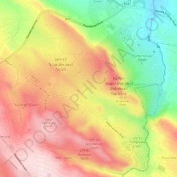
Name: Mogale City Ward 28 topographic map, elevation, terrain.
Average elevation: 5,381 ft
Minimum elevation: 4,751 ft
Maximum elevation: 5,899 ft
Other topographic maps
Click on a map to view its topography, its elevation and its terrain.
Magaliesburg
South Africa > Gauteng > West Rand District Municipality > Mogale City Local Municipality
Magaliesburg, Mogale City Local Municipality, West Rand District Municipality, Gauteng, 1791, South Africa
Average elevation: 4,934 ft
Mogale City
South Africa > Gauteng > West Rand District Municipality > Mogale City Local Municipality
Mogale City, Mogale City Local Municipality, West Rand District Municipality, Gauteng, South Africa
Average elevation: 4,882 ft
Hekpoort
South Africa > Gauteng > West Rand District Municipality > Mogale City Local Municipality > Hekpoort
Hekpoort, Mogale City Local Municipality, West Rand District Municipality, Gauteng, South Africa
Average elevation: 4,193 ft