
Make a donation
Gear up for your next adventure:
As an Amazon Associate, this site earns from qualifying purchases at no extra cost to you.
Warstein topographic map
Click on the map to display elevation.
Make a donation
Gear up for your next adventure:
As an Amazon Associate, this site earns from qualifying purchases at no extra cost to you.
Warstein
Warstein is located north of the Arnsberger Wald (forest), at a brook called Wäster. The area south of the city is mostly forested; the lightly forested Haarstrang mountain is to the north. The river Möhne flows between these two areas. The highest elevation is 581 m (1,906 ft) in the south of the city near a hill called Stimm Stamm; the lowest elevation is 216 m (709 ft) in the village Waldhausen in the north.
Make a donation
Gear up for your next adventure:
As an Amazon Associate, this site earns from qualifying purchases at no extra cost to you.
About this map
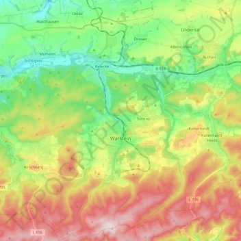
Name: Warstein topographic map, elevation, terrain.
Location: Warstein, Kreis Soest, North Rhine-Westphalia, 59581, Germany (51.38855 8.20178 51.52277 8.40984)
Average elevation: 1,224 ft
Minimum elevation: 732 ft
Maximum elevation: 1,909 ft
Make a donation
Gear up for your next adventure:
As an Amazon Associate, this site earns from qualifying purchases at no extra cost to you.
Other topographic maps
Click on a map to view its topography, its elevation and its terrain.