
Make a donation
Gear up for your next adventure:
As an Amazon Associate, this site earns from qualifying purchases at no extra cost to you.
Lindenberg im Allgäu topographic map
Click on the map to display elevation.
Make a donation
Gear up for your next adventure:
As an Amazon Associate, this site earns from qualifying purchases at no extra cost to you.
About this map
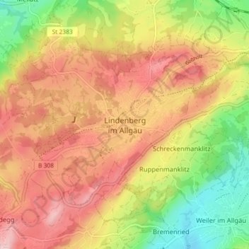
Name: Lindenberg im Allgäu topographic map, elevation, terrain.
Location: Lindenberg im Allgäu, Landkreis Lindau, Bavaria, 88161, Germany (47.58233 9.85888 47.62093 9.93043)
Average elevation: 2,421 ft
Minimum elevation: 1,965 ft
Maximum elevation: 2,802 ft
Make a donation
Gear up for your next adventure:
As an Amazon Associate, this site earns from qualifying purchases at no extra cost to you.
Other topographic maps
Click on a map to view its topography, its elevation and its terrain.
Make a donation
Gear up for your next adventure:
As an Amazon Associate, this site earns from qualifying purchases at no extra cost to you.
Schreckenmanklitz
Germany > Bavaria > Landkreis Lindau > Weiler-Simmerberg
Average elevation: 2,352 ft