
Make a donation
Gear up for your next adventure:
As an Amazon Associate, this site earns from qualifying purchases at no extra cost to you.
Stokesdale topographic map
Click on the map to display elevation.
Make a donation
Gear up for your next adventure:
As an Amazon Associate, this site earns from qualifying purchases at no extra cost to you.
About this map
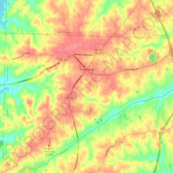
Name: Stokesdale topographic map, elevation, terrain.
Location: Stokesdale, Guilford County, North Carolina, United States (36.19779 -80.03607 36.25752 -79.91700)
Average elevation: 879 ft
Minimum elevation: 732 ft
Maximum elevation: 981 ft
Guilford County trails, hiking, mountain biking, running and outdoor activities
Make a donation
Gear up for your next adventure:
As an Amazon Associate, this site earns from qualifying purchases at no extra cost to you.
Other topographic maps
Click on a map to view its topography, its elevation and its terrain.
Oak Hollow Lake
United States > North Carolina > Guilford County > High Point
Average elevation: 856 ft
Make a donation
Gear up for your next adventure:
As an Amazon Associate, this site earns from qualifying purchases at no extra cost to you.
Make a donation
Gear up for your next adventure:
As an Amazon Associate, this site earns from qualifying purchases at no extra cost to you.
Make a donation
Gear up for your next adventure:
As an Amazon Associate, this site earns from qualifying purchases at no extra cost to you.
Sedgefield Lakes
United States > North Carolina > Guilford County > Greensboro
Average elevation: 863 ft
Make a donation
Gear up for your next adventure:
As an Amazon Associate, this site earns from qualifying purchases at no extra cost to you.
Guilford College
United States > North Carolina > Guilford County > Greensboro > Guilford College
Average elevation: 896 ft
Make a donation
Gear up for your next adventure:
As an Amazon Associate, this site earns from qualifying purchases at no extra cost to you.
Bessemer
United States > North Carolina > Guilford County > Greensboro > Bessemer
Average elevation: 781 ft
North Hyde Park
United States > North Carolina > Guilford County > Greensboro
Average elevation: 837 ft
Make a donation
Gear up for your next adventure:
As an Amazon Associate, this site earns from qualifying purchases at no extra cost to you.