
No Creek topographic map
Interactive map
Click on the map to display elevation.
About this map
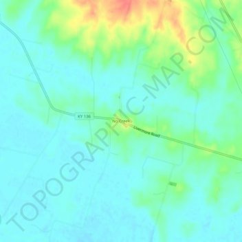
Name: No Creek topographic map, elevation, terrain.
Location: No Creek, Ohio County, Kentucky, United States (37.46060 -86.97833 37.50060 -86.93833)
Average elevation: 423 ft
Minimum elevation: 377 ft
Maximum elevation: 558 ft
Other topographic maps
Click on a map to view its topography, its elevation and its terrain.
Hartford
United States > Kentucky > Ohio County
Hartford, Ohio County, Kentucky, United States
Average elevation: 404 ft
Olaton
United States > Kentucky > Ohio County
Olaton, Ohio County, Kentucky, 42361, United States
Average elevation: 515 ft
Fordsville
United States > Kentucky > Ohio County > Fordsville
Fordsville, Ohio County, Kentucky, United States
Average elevation: 535 ft