
La Estrella topographic map
Interactive map
Click on the map to display elevation.
About this map
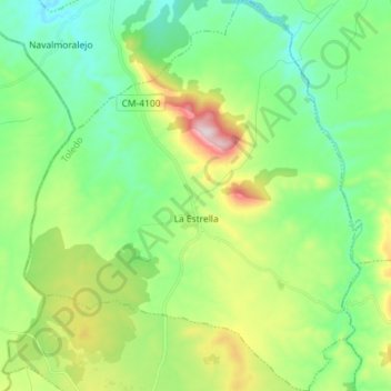
Name: La Estrella topographic map, elevation, terrain.
Location: La Estrella, La Jara, Toledo, Castile-La Mancha, Spain (39.64117 -5.15640 39.75144 -5.03269)
Average elevation: 1,745 ft
Minimum elevation: 1,211 ft
Maximum elevation: 2,999 ft
Other topographic maps
Click on a map to view its topography, its elevation and its terrain.
Santa Ana de Pusa
Spain > Castile-La Mancha > La Jara
Santa Ana de Pusa, La Jara, Toledo, Castile-La Mancha, Spain
Average elevation: 1,942 ft