
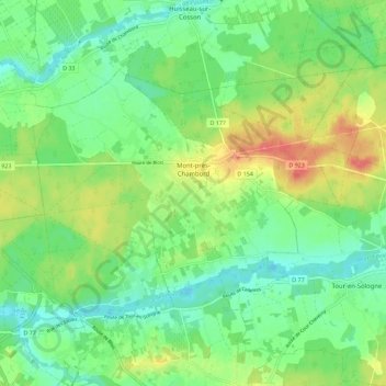
Mont-près-Chambord topographic map
Interactive map
Click on the map to display elevation.
About this map
Name: Mont-près-Chambord topographic map, elevation, terrain.
Average elevation: 299 ft
Minimum elevation: 226 ft
Maximum elevation: 420 ft
Other topographic maps
Click on a map to view its topography, its elevation and its terrain.
Muides-sur-Loire
Frankrijk > Centre-Val de Loire > Loir-et-Cher
Muides-sur-Loire, Blois, Loir-et-Cher, Centre-Val de Loire, Metropolitaans Frankrijk, 41500, Frankrijk
Average elevation: 285 ft
Chémery
Frankrijk > Centre-Val de Loire > Loir-et-Cher
Chémery, Romorantin-Lanthenay, Loir-et-Cher, Centre-Val de Loire, Metropolitaans Frankrijk, 41700, Frankrijk
Average elevation: 348 ft
La Batardière
Frankrijk > Centre-Val de Loire > Loir-et-Cher > Montrichard Val de Cher
La Batardière, Bourré, Montrichard Val de Cher, Romorantin-Lanthenay, Loir-et-Cher, Centre-Val de Loire, Metropolitaans Frankrijk, 41400, Frankrijk
Average elevation: 325 ft
Loire
Frankrijk > Centre-Val de Loire > Loir-et-Cher > La Chaussée-Saint-Victor
Loire, La Chaussée-Saint-Victor, Blois, Loir-et-Cher, Centre-Val de Loire, Metropolitaans Frankrijk, 41260, Frankrijk
Average elevation: 262 ft
Le Mauvais Pas
Frankrijk > Centre-Val de Loire > Loir-et-Cher > Cormenon
Le Mauvais Pas, Cormenon, Vendôme, Loir-et-Cher, Centre-Val de Loire, Metropolitaans Frankrijk, 41170, Frankrijk
Average elevation: 479 ft
Vernou
Frankrijk > Centre-Val de Loire > Loir-et-Cher > Chaumont-sur-Tharonne
Vernou, Chaumont-sur-Tharonne, Romorantin-Lanthenay, Loir-et-Cher, Centre-Val de Loire, Metropolitaans Frankrijk, 41600, Frankrijk
Average elevation: 417 ft
Saint-Bohaire
Frankrijk > Centre-Val de Loire > Loir-et-Cher > Saint-Bohaire
Saint-Bohaire, Blois, Loir-et-Cher, Centre-Val de Loire, Metropolitaans Frankrijk, 41330, Frankrijk
Average elevation: 358 ft