
Selão topographic map
Interactive map
Click on the map to display elevation.
About this map
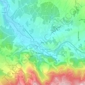
Name: Selão topographic map, elevation, terrain.
Location: Selão, Colares, Sintra, Lisboa, 2705-216, Portugal (38.78417 -9.46454 38.82417 -9.42454)
Average elevation: 358 ft
Minimum elevation: 3 ft
Maximum elevation: 1,171 ft
Other topographic maps
Click on a map to view its topography, its elevation and its terrain.
Ribeira de Colares
Ribeira de Colares, Colares, Sintra, Lisboa, Portugal
Average elevation: 187 ft