
Blahodatne topographic map
Interactive map
Click on the map to display elevation.
About this map
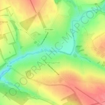
Name: Blahodatne topographic map, elevation, terrain.
Average elevation: 377 ft
Minimum elevation: 246 ft
Maximum elevation: 495 ft
Other topographic maps
Click on a map to view its topography, its elevation and its terrain.
Казанківська селищна громада
Казанківська селищна громада, Bashtanka Raion, Mykolaiv Oblast, Ukraine
Average elevation: 344 ft
Yuzhnoukrainsk
Yuzhnoukrainsk, Южноукраїнська міська громада, Voznesensk Raion, Mykolaiv Oblast, 55000, Ukraine
Average elevation: 328 ft
Інгульська сільська громада
Інгульська сільська громада, Bashtanka Raion, Mykolaiv Oblast, Ukraine
Average elevation: 203 ft
Ochakiv
Ochakiv, Очаківська міська громада, Mykolaiv Raion, Mykolaiv Oblast, 57500, Ukraine
Average elevation: 56 ft
Snihurivka
Snihurivka, Snihurivka Urban Hromada, Bashtanka Raion, Mykolaiv Oblast, 57309, Ukraine
Average elevation: 151 ft
Mykolaiv
Ukraine > Mykolaiv Oblast > Mykolaiv
Mykolaiv, Миколаївська міська громада, Mykolaiv Raion, Mykolaiv Oblast, 54000-54490, Ukraine
Average elevation: 105 ft
Mykolaiv
Ukraine > Mykolaiv Oblast > Mykolaiv
Mykolaiv, Центральний район, Миколаївська міська рада, Mykolaiv Oblast, Ukraine
Average elevation: 105 ft
Mykolaiv
Ukraine > Mykolaiv Oblast > Mykolaiv
Mykolaiv, Центральний район, Mykolaiv, Mykolaiv Oblast, 54000-54490, Ukraine
Average elevation: 128 ft