
Make a donation
Gear up for your next adventure:
As an Amazon Associate, this site earns from qualifying purchases at no extra cost to you.
Buchholz topographic map
Click on the map to display elevation.
Make a donation
Gear up for your next adventure:
As an Amazon Associate, this site earns from qualifying purchases at no extra cost to you.
Buchholz
Buchholz ist seit 1976 der zweitgrößte Ortsbezirk der Stadt Boppard. Die Ortslage liegt auf den Hunsrückhöhen an der Wasserscheide zwischen Rhein und Mosel.
Make a donation
Gear up for your next adventure:
As an Amazon Associate, this site earns from qualifying purchases at no extra cost to you.
About this map
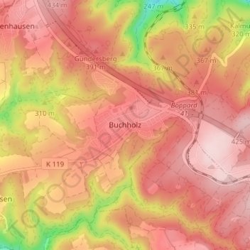
Name: Buchholz topographic map, elevation, terrain.
Average elevation: 1,158 ft
Minimum elevation: 574 ft
Maximum elevation: 1,437 ft
Make a donation
Gear up for your next adventure:
As an Amazon Associate, this site earns from qualifying purchases at no extra cost to you.
Other topographic maps
Click on a map to view its topography, its elevation and its terrain.