
SS7, Petaling Jaya topographic map
Interactive map
Click on the map to display elevation.
About this map
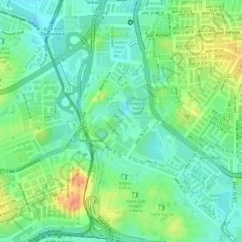
Name: SS7, Petaling Jaya topographic map, elevation, terrain.
Average elevation: 108 ft
Minimum elevation: 43 ft
Maximum elevation: 203 ft
Other topographic maps
Click on a map to view its topography, its elevation and its terrain.
Sungai Penchala
Malaysia > Selangor > Petaling Jaya
Sungai Penchala, Sungai Way, Petaling Jaya, Petaling, Selangor, Malaysia
Average elevation: 89 ft
PJS10
Malaysia > Selangor > Petaling Jaya > PJS10
PJS10, Petaling Jaya, Selangor, 46150 PETALING JAYA, Malaysia
Average elevation: 85 ft