
Santa Catalina Island topographic map
Click on the map to display elevation.
Gear up for your next adventure:
As an Amazon Associate, this site earns from qualifying purchases at no extra cost to you.
Santa Catalina Island
Catalina is primarily composed of two distinct rock units: Catalina Schist from the Early Cretaceous (95 to 109 million years ago), and Miocene volcanic and intrusive igneous rocks. The island is rich in quartz, to the extent that some beaches on the seaward side have silvery-grey sand. These formations originally occurred on the ocean floor and emerged from the ocean through tectonic activity. This means that the Santa Catalina Island land-mass was never directly connected to mainland California. Other geologic factors that contributed to the island topography include further geologic uplift and subsidence, tectonic plate movement, sedimentation, metamorphic activity, weathering, and erosion.
About this map
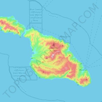
Name: Santa Catalina Island topographic map, elevation, terrain.
Average elevation: 197 ft
Minimum elevation: 0 ft
Maximum elevation: 2,090 ft
Los Angeles County trails, hiking, mountain biking, running and outdoor activities