
Noorbeek topographic map
Interactive map
Click on the map to display elevation.
About this map
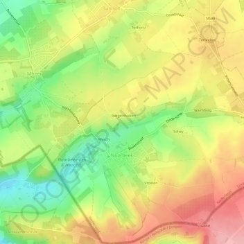
Name: Noorbeek topographic map, elevation, terrain.
Location: Noorbeek, Eijsden-Margraten, Limburg, Nederland (50.75589 5.79324 50.79139 5.84504)
Average elevation: 564 ft
Minimum elevation: 351 ft
Maximum elevation: 758 ft
Noorbeek ligt op het Plateau van Margraten op de zuidoostflank van het dal van de Noor, die iets ten noorden van de dorpskern in de buurtschap Wesch ontspringt. De hoogte van Noorbeek bedraagt ongeveer 150 meter.
Other topographic maps
Click on a map to view its topography, its elevation and its terrain.