
บ้านทุ่งเคล็ด topographic map
Interactive map
Click on the map to display elevation.
About this map
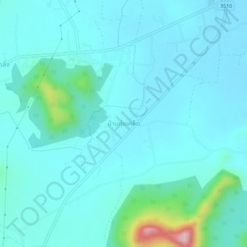
Name: บ้านทุ่งเคล็ด topographic map, elevation, terrain.
Location: บ้านทุ่งเคล็ด, จังหวัดเพชรบุรี, Thailand (12.89391 99.71062 12.93391 99.75062)
Average elevation: 256 ft
Minimum elevation: 121 ft
Maximum elevation: 1,178 ft