
Istmo de Suaces topographic map
Interactive map
Click on the map to display elevation.
About this map
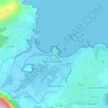
Name: Istmo de Suaces topographic map, elevation, terrain.
Location: Istmo de Suaces, Noja, Trasmiera, Cantabria, 39180, España (43.48189 -3.54496 43.50189 -3.52496)
Average elevation: 46 ft
Minimum elevation: -3 ft
Maximum elevation: 656 ft
Other topographic maps
Click on a map to view its topography, its elevation and its terrain.
Barrio Castrejón
España > Cantabria > Noja > Barrio Castrejón
Barrio Castrejón, Noja, Trasmiera, Cantabria, 39180, España
Average elevation: 79 ft
Playa de Peña Pombera
Playa de Peña Pombera, Calle de la Costa, Noja, Trasmiera, Cantabria, 39180, España
Average elevation: 20 ft
Playa de Tregandín
Playa de Tregandín, Paseo de Trengandín, Barrio El Arco, Noja, Trasmiera, Cantabria, 39180, España
Average elevation: 72 ft