
Msaken topographic map
Interactive map
Click on the map to display elevation.
About this map
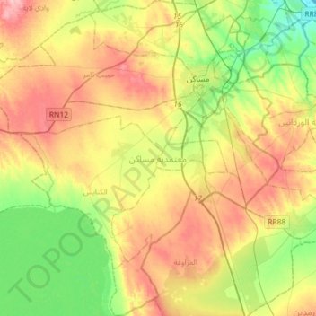
Name: Msaken topographic map, elevation, terrain.
Location: Msaken, Sousse, Tunisie (35.55684 10.38116 35.79087 10.64850)
Average elevation: 203 ft
Minimum elevation: 0 ft
Maximum elevation: 456 ft
Other topographic maps
Click on a map to view its topography, its elevation and its terrain.
El Kalaa Essghira Est
El Kalaa Essghira Est, Kalaa Sghira, Sousse, 4021, Tunisie
Average elevation: 148 ft