
Argenton-sur-Creuse topographic map
Interactive map
Click on the map to display elevation.
About this map
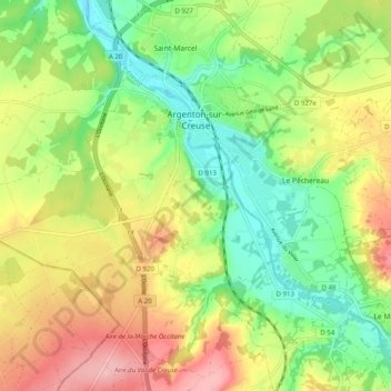
Name: Argenton-sur-Creuse topographic map, elevation, terrain.
Average elevation: 538 ft
Minimum elevation: 318 ft
Maximum elevation: 827 ft
Other topographic maps
Click on a map to view its topography, its elevation and its terrain.
Thenay
France > Centre-Val de Loire > Indre
Thenay, Le Blanc, Indre, Centre-Val de Loire, France métropolitaine, 36800, France
Average elevation: 499 ft
Buzançais
France > Centre-Val de Loire > Indre
Buzançais, Châteauroux, Indre, Centre-Val de Loire, France métropolitaine, 36500, France
Average elevation: 427 ft