
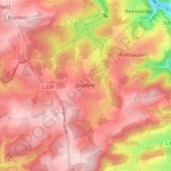
Glörfeld topographic map
Interactive map
Click on the map to display elevation.
About this map
Name: Glörfeld topographic map, elevation, terrain.
Average elevation: 1,234 ft
Minimum elevation: 699 ft
Maximum elevation: 1,450 ft
Other topographic maps
Click on a map to view its topography, its elevation and its terrain.
Neuemühle
Deutschland > Nordrhein-Westfalen > Märkischer Kreis > Halver
Neuemühle, Halver, Märkischer Kreis, Nordrhein-Westfalen, 58553, Deutschland
Average elevation: 1,286 ft
Othmaringhausen
Deutschland > Nordrhein-Westfalen > Märkischer Kreis > Halver
Othmaringhausen, Halver, Märkischer Kreis, Nordrhein-Westfalen, 58553, Deutschland
Average elevation: 1,155 ft
Schmidtsiepen
Deutschland > Nordrhein-Westfalen > Märkischer Kreis > Halver
Schmidtsiepen, Halver, Märkischer Kreis, Nordrhein-Westfalen, 58553, Deutschland
Average elevation: 1,201 ft
Halverscheid
Deutschland > Nordrhein-Westfalen > Märkischer Kreis > Halver
Halverscheid, Halver, Märkischer Kreis, Nordrhein-Westfalen, 58579, Deutschland
Average elevation: 1,076 ft
Grünenbaum
Deutschland > Nordrhein-Westfalen > Märkischer Kreis > Halver > Glörfeld > Grünenbaum
Grünenbaum, Glörfeld, Halver, Märkischer Kreis, Nordrhein-Westfalen, 58339, Deutschland
Average elevation: 1,263 ft