Geolocate

Georgetown topographic map

Click on the map to display elevation.

About this map

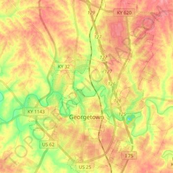
Name: Georgetown topographic map, elevation, terrain.

Location: Georgetown, Scott County, Kentucky, 40324, United States (38.17693 -84.60252 38.27794 -84.50419)

Average elevation: 869 ft

Minimum elevation: 725 ft

Maximum elevation: 971 ft

Scott County trails, hiking, mountain biking, running and outdoor activities

Other topographic maps

Click on a map to view its topography, its elevation and its terrain.

Skinnersburg

United States > Kentucky > Scott County

Average elevation: 889 ft

Herdon

United States > Kentucky > Scott County

Average elevation: 866 ft

Double Culvert

United States > Kentucky > Scott County

Average elevation: 906 ft

Gear up for your next adventure:

🪑Portable Camp Table - Compact table for campsite meals
🔋Rechargeable Batteries - Power up your outdoor devices
🪑Ultralight Camp Chairs - Portable seating for resting after a long day of mapping
🥾Hiking Shoes - Durable and comfortable shoes for trail hiking
🌎3D Topographic Globes - Raised relief globes for a tactile understanding of geography

As an Amazon Associate, this site earns from qualifying purchases at no extra cost to you.