
Brisas Del Oponcito topographic map
Interactive map
Click on the map to display elevation.
About this map
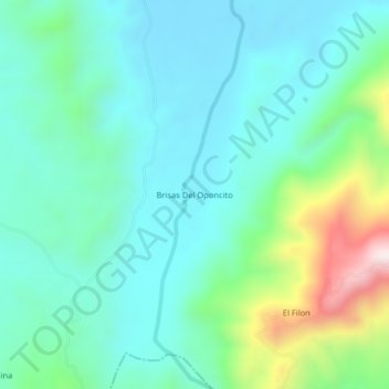
Name: Brisas Del Oponcito topographic map, elevation, terrain.
Average elevation: 1,138 ft
Minimum elevation: 663 ft
Maximum elevation: 2,753 ft
Other topographic maps
Click on a map to view its topography, its elevation and its terrain.
Guamales
Colombia > Santander > San Vicente de Chucurí
Guamales, San Vicente de Chucurí, Yariguíes, Santander, RAP Gran Santander, Colombia
Average elevation: 4,042 ft
La Colorada
Colombia > Santander > San Vicente de Chucurí
La Colorada, San Vicente de Chucurí, Yariguíes, Santander, RAP Gran Santander, Colombia
Average elevation: 367 ft
Llana Caliente
Colombia > Santander > San Vicente de Chucurí
Llana Caliente, San Vicente de Chucurí, Yariguíes, Santander, RAP Gran Santander, Colombia
Average elevation: 692 ft
Llana Fria - Borneo
Colombia > Santander > San Vicente de Chucurí
Llana Fria - Borneo, San Vicente de Chucurí, Yariguíes, Santander, RAP Gran Santander, Colombia
Average elevation: 2,037 ft
Tempestuosa
Colombia > Santander > San Vicente de Chucurí > Tempestuosa
Tempestuosa, San Vicente de Chucurí, Yariguíes, Santander, Colombia
Average elevation: 741 ft