
Manhouce topographic map
Interactive map
Click on the map to display elevation.
About this map
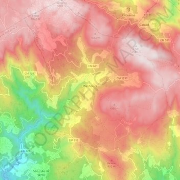
Name: Manhouce topographic map, elevation, terrain.
Location: Manhouce, São Pedro do Sul, Viseu, Portugal (40.77802 -8.25509 40.86469 -8.15958)
Average elevation: 2,343 ft
Minimum elevation: 315 ft
Maximum elevation: 3,658 ft
Other topographic maps
Click on a map to view its topography, its elevation and its terrain.
Sobral
Portugal > Viseu > São Pedro do Sul > Pinho
Sobral, Pinho, São Pedro do Sul, Viseu, Portugal
Average elevation: 1,286 ft
Rio de Mel
Portugal > Viseu > São Pedro do Sul > Pindelo dos Milagres
Rio de Mel, Pindelo dos Milagres, São Pedro do Sul, Viseu, Portugal
Average elevation: 1,329 ft