
Saalfelder Höhe topographic map
Interactive map
Click on the map to display elevation.
About this map
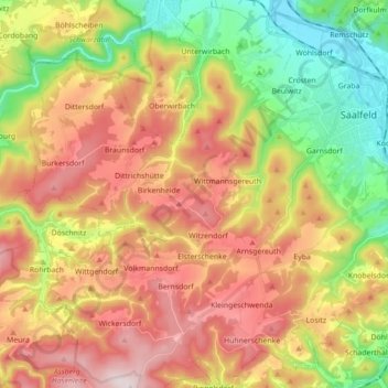
Name: Saalfelder Höhe topographic map, elevation, terrain.
Average elevation: 1,555 ft
Minimum elevation: 653 ft
Maximum elevation: 2,507 ft
Other topographic maps
Click on a map to view its topography, its elevation and its terrain.
Aue am Berg
Deutschland > Thüringen > Saalfeld/Saale > Aue am Berg
Aue am Berg, Saalfeld/Saale, Landkreis Saalfeld-Rudolstadt, Thüringen, 07318, Deutschland
Average elevation: 1,070 ft
Reichmannsdorf
Deutschland > Thüringen > Saalfeld/Saale
Reichmannsdorf, Saalfeld/Saale, Landkreis Saalfeld-Rudolstadt, Thüringen, Deutschland
Average elevation: 2,037 ft
Dittersdorfer Höhe
Deutschland > Thüringen > Saalfeld/Saale
Dittersdorfer Höhe, Saalfeld/Saale, Landkreis Saalfeld-Rudolstadt, Thüringen, 07427, Deutschland
Average elevation: 1,637 ft