
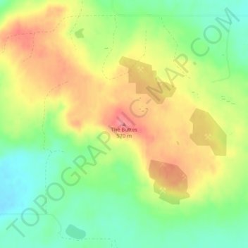
The Buttes topographic map
Interactive map
Click on the map to display elevation.
About this map
Name: The Buttes topographic map, elevation, terrain.
Average elevation: 1,736 ft
Minimum elevation: 1,611 ft
Maximum elevation: 1,867 ft
Other topographic maps
Click on a map to view its topography, its elevation and its terrain.
New England
United States of America > North Dakota > New England
New England, Hettinger County, North Dakota, 58647, United States of America
Average elevation: 2,602 ft
Leith
United States of America > North Dakota > Leith
Leith, Grant County, North Dakota, United States of America
Average elevation: 2,343 ft
Drake
United States of America > North Dakota > Drake
Drake, McHenry County, North Dakota, United States of America
Average elevation: 1,640 ft
Grenora
United States of America > North Dakota > Grenora
Grenora, Williams County, North Dakota, United States of America
Average elevation: 2,100 ft
Hickson
United States of America > North Dakota > Hickson
Hickson, Cass County, North Dakota, United States of America
Average elevation: 919 ft