
Vinita topographic map
Interactive map
Click on the map to display elevation.
About this map
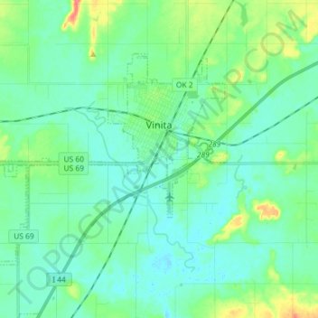
Name: Vinita topographic map, elevation, terrain.
Location: Vinita, Craig County, Oklahoma, 74301, United States (36.58978 -95.26966 36.66675 -95.12560)
Average elevation: 699 ft
Minimum elevation: 656 ft
Maximum elevation: 850 ft
Vinita is located in northeastern Oklahoma, a region of the state known as Green Country. According to the Vinita Chamber of Commerce, the town is often called the "Crossroads to Green Country." It sits at the base of the Ozark Highlands topographical region in a mix of prairie and forest. It is located in southern Craig County at 36°38′28″N 95°9′24″W / 36.64111°N 95.15667°W / 36.64111; -95.15667 (36.641193, −95.156676). According to the United States Census Bureau, the city has a total area of 6.0 square miles (15.5 km2), all land. Vinita is in a valley.
Other topographic maps
Click on a map to view its topography, its elevation and its terrain.
Bluejacket
United States > Oklahoma > Craig County
Bluejacket, Craig County, Oklahoma, United States
Average elevation: 778 ft
Welch
United States > Oklahoma > Craig County
Welch, Craig County, Oklahoma, United States
Average elevation: 830 ft
Centralia
United States > Oklahoma > Craig County
Centralia, Craig County, Oklahoma, United States
Average elevation: 840 ft
White Oak
United States > Oklahoma > Craig County
White Oak, Craig County, Oklahoma, United States
Average elevation: 761 ft
Ketchum
United States > Oklahoma > Craig County
Ketchum, Craig County, Oklahoma, United States
Average elevation: 784 ft
Big Cabin
United States > Oklahoma > Craig County
Big Cabin, Craig County, Oklahoma, 74332, United States
Average elevation: 709 ft