
Chhota Bhanuja topographic map
Interactive map
Click on the map to display elevation.
About this map
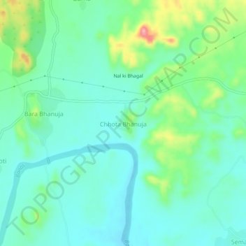
Name: Chhota Bhanuja topographic map, elevation, terrain.
Average elevation: 2,113 ft
Minimum elevation: 1,995 ft
Maximum elevation: 2,461 ft
Other topographic maps
Click on a map to view its topography, its elevation and its terrain.
Khamnor
India > Rajasthan > Khamnor Tehsil
Khamnor, Khamnor Tehsil, Rajsamand District, Rajasthan, 313322, India
Average elevation: 2,024 ft
Jhalon Ki Madar
India > Rajasthan > Khamnor Tehsil
Jhalon Ki Madar, Khamnor Tehsil, Rajsamand District, Rajasthan, India
Average elevation: 2,398 ft